












Arabic version: مدّات منخفضة للغاية تجذب الآلاف للمشي إلى منارة بوين
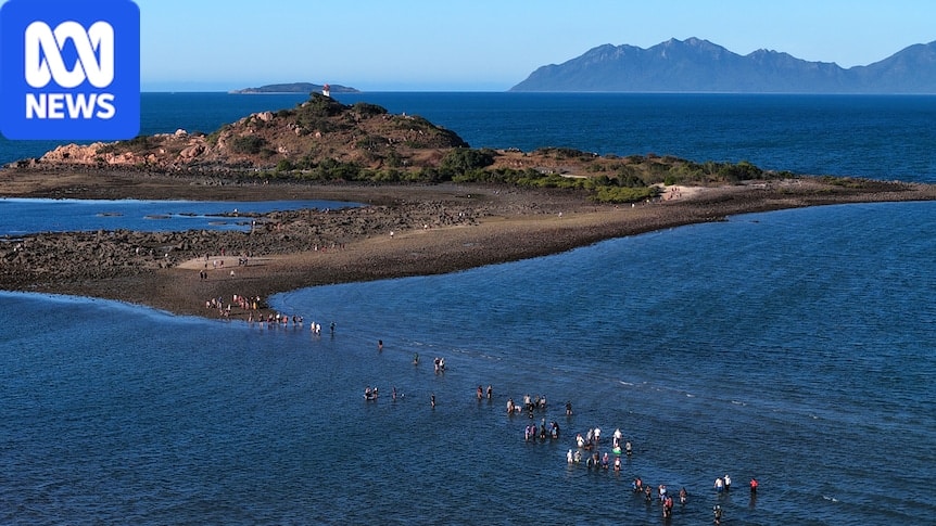
Ultra-low tides have opened a rare opportunity for people to walk from Bowen to the North Head Island lighthouse, about 1 kilometre offshore, drawing hundreds of trekkers to the North Queensland town, though there was no official count.
According to ABC News, the walk is accessible for five days this year because of unusually low winter tides that coincide with the new moon, and the crossing takes about one hour each way. Bowen Tourism Association estimated hundreds of people trekked to the lighthouse over three days this week.
Wading through water, the walkers set out from Bowen, about 200 kilometres north of Mackay, to reach the North Head Island lighthouse. Bowen Tourism Association’s Leanne Abernethy said the popular walk was also usually possible for two days a year in July or August. “How many days the walk is possible depends on the tides,” she said. She added the walk provides an economic boost to the town as people travel especially for the walk and often stay for a few days.
The six-sided lighthouse on North Head Island is one of Queensland’s oldest surviving maritime structures. It was originally built in 1866 to guide ships through the waters of Port Denison and was decommissioned in 1985. The last chance to walk to the lighthouse this year is August 11 and 12.
Bowen resident Trudy Starkey said seeing live coral, red starfish and sea slugs was part of the experience and praised how respectful people were toward the sea life. Sisters Nakita and Ta-qusha Hegarty from Bowen made the trek for the first time and said despite sore legs and cold water, the view and the sea creatures they encountered made it worthwhile.
CSIRO oceanographer Clothilde Langlais said tidal differences were also influenced by the Great Barrier Reef and that the region from Mackay south to the Broad Sound strait had the biggest difference between high and low tide on the east coast of Australia. Mackay’s tidal range is about 6 metres, while areas of the Broad Sound strait have up to 9 metres of variation. In 2025, there were no days when the water was below 0.2 metres, the recommended safe level.
Dr Langlais said the tidal variation created mudflats that are home to crustaceans, migratory birds and seagrasses. “They can stabilise the sediment and they’re very good at sequestering carbon as well,” she said. “These mudflats are a very key ecosystem to protect the whole area.”
Photographer Jeff Jones, who has spent decades documenting the region, said changing winds and tidal patterns produce unique patterns and streaks of colour in the tidal system, and he hopes his images encourage others to protect the environment.
Related sections: Australia/استراليا | Western Australia | Queensland | General | Social/إجتماعية